New Seabed Mapping Strengthens Ascension Island Conservation Efforts
South Atlantic marine protected area safeguards astonishing variety of wildlife

The seabed surrounding Ascension Island—home to one of the world’s largest marine protected areas (MPAs)—abounds with volcanic features, submarine landslides, channels, seamounts, and submerged lava flows, new maps show.
The British Geological Survey (BGS) recently announced completion of maps that will help scientists better understand some of the habitat for the rich biodiversity around Ascension, an 34-square-mile (88-square-kilometer) island in the South Atlantic Ocean midway between Angola and Brazil. This pioneering effort, revealed in April, provides unprecedented insight into the underwater landscape of this remote place and represents an important step forward in effective protection of its unique marine ecosystems. Among other things, the mapping for the first time revealed the precise locations of known shipwrecks and some possible—though unverified—wrecks that were previously unknown.
Importantly, the substrate mapping, which focused on nearshore areas composed of sandy sediment and rocky outcrops, will help scientists better understand these fundamental habitats for marine communities.
A treasure trove of biodiversity
Ascension Island harbors an incredible abundance of wildlife above and below the waves, including many migratory species such as tuna, marlin, and sailfish. Marine mammals, including bottlenose dolphins, humpback whales, and sperm whales, regularly visit the area, and these waters are home to 11 fish species found nowhere else on Earth.
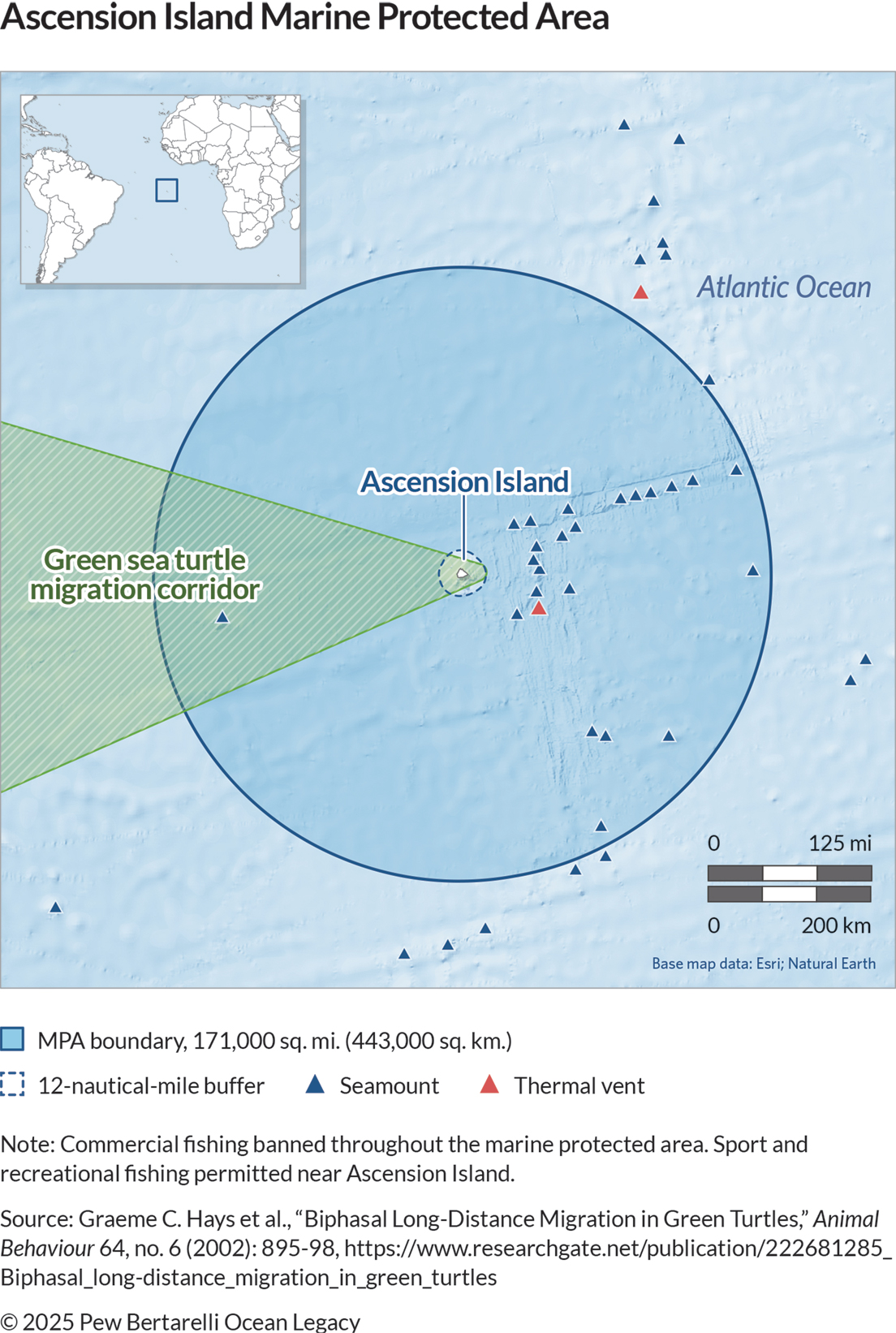
The island hosts the second-largest nesting population of green sea turtles in the South Atlantic. These animals make an incredible journey from Ascension to their feeding grounds in Brazil and the Caribbean Sea before returning to the beaches of their birth once they reach maturity—a cycle that can take decades. Hunting, which had decimated the green sea turtle population, was banned in the 1930s. The species’ numbers have been recovering since the 1970s, representing a conservation success story that continues to unfold. And since the eradication of feral cats from Ascension in 2009, seabird populations have rebounded dramatically, with the island now supporting more than 500,000 seabirds across 11 species.
Mapping the unknown
Until this mapping project, scientists had a limited understanding of the seabed around Ascension Island. The BGS Marine team conducted high-resolution bathymetry (depth) surveys and drop-camera sampling within the nearshore areas of the island, venturing into territories never before surveyed. Using advanced technology including bathymetry, backscatter (seabed composition), and ground-truth sampling (underwater video footage), they created detailed maps.
“Collecting data in such a remote and exposed location was a challenge, but an absolute privilege and pleasure,” said Rhys Cooper, BGS project manager and senior surveyor. “BGS had to adapt existing technology to work with the available survey platform within the limits of Ascension’s wonderfully varied and unpredictable operating environment.”
Strengthening conservation through knowledge and data
This is another important step in preserving this unique ecosystem. In 2019, following the UK government’s agreement to support the Ascension Island Council’s designation proposal, a 171,000-square-mile (443,000-square-kilometer) marine protected area was created, encompassing the island’s entire exclusive economic zone. Pew Bertarelli Ocean Legacy, partnering directly with the local government, provided support for this designation and has since assisted efforts to strengthen its management through cutting-edge technology. This includes working with Global Fishing Watch Marine Manager, a platform that uses satellite data to track and monitor a wide range of ocean conditions and fishing activities, as well as a separate initiative that measures biodiversity through environmental DNA sampling.
The BGS team trained the Ascension Island Government (AIG) Conservation Team to use Geographic Information System (GIS) mapping software that integrates location with other data to view, edit, query, and manipulate information, thereby building local capacity to update the maps as new information becomes available.
“AIG are excited to have access to such high-quality bathymetry and habitat maps,” said Tiffany Simpson, AIG’s director of conservation and fisheries. “They will be transformative in our nearshore research and monitoring and allow for much more evidence-based conservation management.”
A model for marine conservation
The Ascension Island MPA exemplifies the UK’s commitment to marine conservation through its ambitious Blue Belt Programme, which supports the UK Overseas Territories with the protection and sustainable management of their marine environments.
The combination of comprehensive protection and cutting-edge scientific research at Ascension Island demonstrates how modern conservation can work when backed by political will and scientific expertise. Amid unprecedented challenges to ocean health globally, such initiatives provide hope and a potential model for marine conservation elsewhere. The delivery of these groundbreaking maps represents another significant step toward understanding and protecting one of our planet’s most special marine environments.
Johnny Briggs works on Pew Bertarelli Ocean Legacy.


